Geography
Fauna
The island of Aruba, being isolated from the main land of South America, has helped the evolution of multiple endemic animals. The island provides a habitat for the endemic Aruban Whiptail and Aruba Rattlesnake, as well as endemic subspecies of Burrowing Owl and Brown-throated Parakeet.
The rattlesnake and the owl are printed on the Aruban currency
Flora
The flora of Aruba differs from the typical tropical island vegetation. Xeric scrublands are common, with various forms of cacti, thorny shrubs and evergreens. With the most known plant being the Aloe vera, which has a place on the Coat of Arms of Aruba.

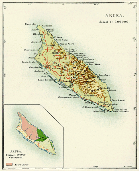
Natural bridge in Aruba (collapsed 2 September 2005) Aruba is a generally flat, riverless island in the Leeward Antilles island arc of the Lesser Antilles in the southern part of the Caribbean. It has white sandy beaches on the western and southern coasts of the island, relatively sheltered from fierce ocean currents.[11] This is where most tourist development has occurred.[11] The northern and eastern coasts, lacking this protection, are considerably more battered by the sea and have been left largely untouched by humans. The hinterland of the island features some rolling hills, the best known of which are called Hooiberg at 165 meters (541 ft) and Mount Jamanota, the highest on the island at 188 meters (617 ft) above sea level. Oranjestad, the capital, is located at 12°19′N70°1′W. To the east of Aruba are Bonaire and Curaçao, two island territories which once formed the southwest part of the Netherlands Antilles. This group of islands is sometimes called the ABC islands. They are located on the South American continental shelf and therefore geographically listed as part of South America. The Natural Bridge was a large, naturally formed limestone bridge on the island's north shore. It was a popular tourist destination until its collapse in 2005.
Cities and towns
The island, with a population of just over 100,000 inhabitants, does not have major cities. However, most of the island's population resides in or surrounding the two major city-like districts of Oranjestad (Capital) and San Nicolaas. Furthermore, the island is divided into six districts, which are:
• Noord
• Oranjestad (33,000 in 2006), divided in two districts
• Paradera
• San Nicolaas, divided in two districts
• Santa Cruz
• Savaneta
Climate
| hideClimate data for Oranjestad, Aruba (1981–2010, extremes 1951–2010) | |||||||||||||
| Month | Jan | Feb | Mar | Apr | May | Jun | Jul | Aug | Sep | Oct | Nov | Dec | Year |
| Record high °C (°F) | 32.5 (90.5) | 33.0 (91.4) | 33.9 (93) | 34.4 (93.9) | 34.9 (94.8) | 35.2 (95.4) | 35.3 (95.5) | 36.1 (97) | 36.5 (97.7) | 35.4 (95.7) | 35.0 (95) | 34.8 (94.6) | 36.5 (97.7) |
| Average high °C (°F) | 30.0 (86) | 30.4 (86.7) | 30.9 (87.6) | 31.5 (88.7) | 32.0 (89.6) | 32.2 (90) | 32.0 (89.6) | 32.6 (90.7) | 32.7 (90.9) | 32.1 (89.8) | 31.3 (88.3) | 30.4 (86.7) | 31.5 (88.7) |
| Daily mean °C (°F) | 26.7 (80.1) | 26.8 (80.2) | 27.2 (81) | 27.9 (82.2) | 28.5 (83.3) | 28.7 (83.7) | 28.6 (83.5) | 29.1 (84.4) | 29.2 (84.6) | 28.7 (83.7) | 28.1 (82.6) | 27.2 (81) | 28.1 (82.6) |
| Average low °C (°F) | 24.5 (76.1) | 24.7 (76.5) | 25.0 (77) | 25.8 (78.4) | 26.5 (79.7) | 26.7 (80.1) | 26.4 (79.5) | 26.8 (80.2) | 26.9 (80.4) | 26.4 (79.5) | 25.8 (78.4) | 25.0 (77) | 25.9 (78.6) |
| Record low °C (°F) | 21.3 (70.3) | 20.6 (69.1) | 21.4 (70.5) | 21.5 (70.7) | 21.8 (71.2) | 22.7 (72.9) | 21.2 (70.2) | 21.3 (70.3) | 22.1 (71.8) | 21.9 (71.4) | 22.0 (71.6) | 20.5 (68.9) | 20.5 (68.9) |
| Average precipitation mm (inches) | 39.3 (1.547) | 20.6 (0.811) | 8.7 (0.343) | 11.6 (0.457) | 16.3 (0.642) | 18.7 (0.736) | 31.7 (1.248) | 25.8 (1.016) | 45.5 (1.791) | 77.8 (3.063) | 94.0 (3.701) | 81.8 (3.22) | 471.8 (18.575) |
| Average precipitation days (≥ 1.0 mm) | 8.4 | 5.0 | 1.8 | 1.9 | 2.2 | 2.8 | 4.9 | 4.3 | 3.9 | 7.4 | 10.6 | 11.4 | 64.6 |
| Average relative humidity (%) | 77.5 | 76.1 | 75.7 | 77.1 | 77.9 | 77.4 | 77.8 | 76.2 | 76.8 | 78.6 | 79.1 | 78.4 | 77.4 |
| Source: DEPARTAMENTO METEOROLOGICO ARUBA | |||||||||||||