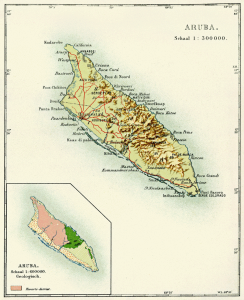
Aruba
Orangestad, The Capital Of Aruba Island
Aruba is a constituent country of the Kingdom of the Netherlands in the southern Caribbean Sea, located about 1,600 kilometres (990 mi) west of the main part of the Lesser Antilles and 29 kilometres (18 mi)[5] north of the coast of Venezuela. It measures 32 kilometres (20 mi) long from its northwestern to its southeastern end and 10 kilometres (6 mi) across at its widest point.[5] Together with Bonaire and Curaçao, Aruba forms a group referred to as the ABC islands. Collectively, Aruba and the other Dutch islands in the Caribbean are often called the Dutch Caribbean.
Aruba is one of the four countries that form the Kingdom of the Netherlands, along with the Netherlands, Curaçao and Sint Maarten. The citizens of these countries all share a single nationality: Dutch. Aruba has no administrative subdivisions, but, for census purposes, is divided into eight regions. Its capital is Oranjestad.
Unlike much of the Caribbean region, Aruba has a dry climate and an arid, cactus-strewn landscape. This climate has helped tourism as visitors to the island can reliably expect warm, sunny weather. It has a land area of 179 km2 (69.1 sq mi) and is densely populated, with a total of 102,484 inhabitants at the 2010 Census. It lies outside Hurricane Alley.
History
The capital, Oranjestad Aruba’s first inhabitants are thought to have been Caquetío Amerindians from the Arawak tribe, who migrated there from Venezuela to escape attacks by the Caribs. Fragments of the earliest known Indian settlements date back to 1000 AD. As sea currents made canoe travel to other Caribbean islands difficult, Caquetio culture remained more closely associated with that of mainland South America. Europeans first learned of Aruba following the explorations for Spain by Amerigo Vespucci and Alonso de Ojeda in the summer of 1499. Both described Aruba as an “island of giants”, remarking on the comparatively large stature of the native Caquetíos compared to Europeans. Gold was not discovered on Aruba for another 300 years.
Move towards independence
In August 1947, Aruba presented its first Staatsreglement (constitution), for Aruba’s status aparte as an autonomous state within the Kingdom of the Netherlands. By 1954, the Charter of the Kingdom of the Netherlands was established, providing a framework for relations between Aruba and the rest of the Kingdom.[9]
Infrastructure

Palm Beach Aruba's Queen Beatrix International Airport is located near Oranjestad. According to the Aruba Airport Authority, almost 1.7 million travelers used the airport in 2005, 61% of whom were Americans. Aruba has two ports, Barcadera beach and Playa, which are located in Oranjestad and Barcadera. The Port of Playa services all the cruise-ship lines, including Royal Caribbean, Carnival Cruise Lines, NCL, Holland America Line, Disney Cruise Line and others. Nearly one million tourists enter this port per year. Aruba Ports Authority, owned and operated by the Aruban government, runs these seaports. Arubus is a government-owned bus company. Its buses operate from 3:30 a.m. until 12:30 a.m., 365 days a year. Small private vans also provide transportation services in certain areas such Hotel Area, San Nicolaas, Santa Cruz and Noord. A street car service runs on rails on the Mainstreet
Government

Map of the European Union in the world with overseas countries and territories and outermost regions

King Willem-Alexander is the head of state of Aruba

FredisRefunjol is the Governor of Aruba

Parliament of Aruba in Oranjestad
As a constituent country of the Kingdom of the Netherlands, Aruba's politics take place within a framework of a 21-member Parliament and an eight-member Cabinet. The governor of Aruba is appointed for a six-year term by the monarch, and the prime minister and deputy prime minister are elected by the Staten (or "Parlamento") for four-year terms. The Staten is made up of 21 members elected by direct, popular vote to serve a four-year term.[15]
Together with the Netherlands, the countries of Aruba, Curaçao and Sint Maarten form the Kingdom of the Netherlands.
As they share the same Dutch citizenship, these four countries still also share the Dutch passport as the Kingdom of the Netherlands passport. As Aruba, Curaçao and Sint Maarten have small populations, the three countries had to limit immigration. To protect their population, they have the right to control the admission and expulsion of people from the Netherlands.
Aruba is designated as a member of the Overseas Countries and Territories (OCT) and is thus officially not a part of the European Union, though Aruba can and does receive support from the European Development Fund
Demographics

Population of Aruba 1961–2003, according to the FAO in 2005; number of inhabitants given in thousands The population is estimated to be 75% mixed European/Amerindian, 15% Black and 10% other ethnicities. The Arawak heritage is stronger on Aruba than on most Caribbean islands. Although no full-blooded Aboriginals remain, the features of the islanders clearly indicate their genetic Arawak heritage. Most of the population is descended from Caquetio Indians and Dutch and to a lesser extent of Africans, Spanish, Portuguese, English, French, and Sephardic Jewish ancestors.
Geography

Natural bridge in Aruba (collapsed 2 September 2005) Aruba is a generally flat, riverless island in the Leeward Antilles island arc of the Lesser Antilles in the southern part of the Caribbean. It has white sandy beaches on the western and southern coasts of the island, relatively sheltered from fierce ocean currents.[11] This is where most tourist development has occurred.[11] The northern and eastern coasts, lacking this protection, are considerably more battered by the sea and have been left largely untouched by humans. The hinterland of the island features some rolling hills, the best known of which are called Hooiberg at 165 meters (541 ft) and Mount Jamanota, the highest on the island at 188 meters (617 ft) above sea level. Oranjestad, the capital, is located at 12°19′N70°1′W. To the east of Aruba are Bonaire and Curaçao, two island territories which once formed the southwest part of the Netherlands Antilles. This group of islands is sometimes called the ABC islands.